
GIS Mapping of Rail Trespass and Suicide
Trespass and suicide incidents can occur at almost any location along railroad rights-of-way. Mapping where and when these incidents take place may help the Federal Railroad Administration (FRA) and rail carriers understand why a particular incident occurred.
One way to do this is with geographic information systems (GIS). GIS mapping can uncover valuable information, including the following:
- Additional data for a particular incident, such as demographic characteristics like age.
- Areas that have high incident rates. Researchers can focus on hotspots and explore why they have concentrations of incidents and consider pilot tests to reduce these numbers.
- Environmental or societal factors that can influence where and when an incident occurs.
- Geo-located incidents tied to other details, such as time, date, and age of victims.
- Insight into why trespassing is common in certain areas. There may be worn paths or communities that need to cross tracks.
- Relationships between incident locations and characteristics of census data from nearby communities. By understanding these relationships, researchers and policy makers can pinpoint locations surrounding rail property where certain countermeasures may be effective.
Current Status
FRA and the U.S. DOT Volpe Center often use GIS analyses when working with a new rail carrier as a first step toward understanding issues specific to the carrier’s system. While individual rail carriers often keep detailed maps of their own systems, additional insight may be gained by comparing common features of areas where suicide and trespass fatalities occur nationally.
Volpe is developing a national map of rail fatalities. As the sample size grows and more railroads provide data, this map will become even more useful and may be a powerful tool for anticipating hotspots.
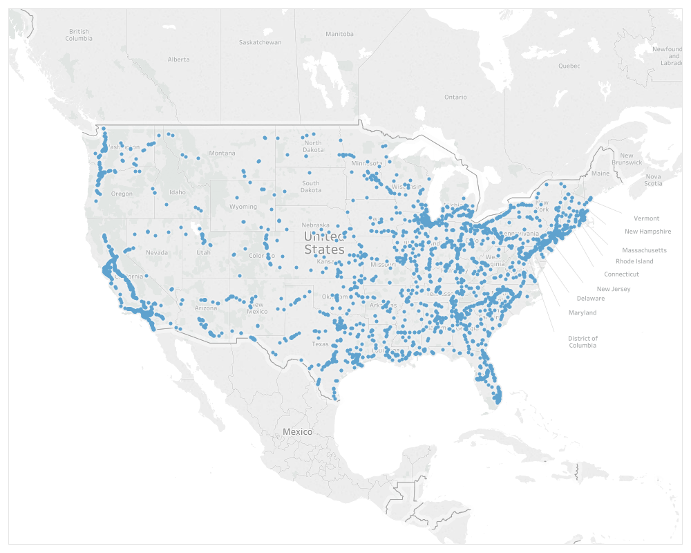
FRA also developed a new interactive dashboard, The Trespass and Suicide Dashboard, to help analyze trespass and suicide incidents that occurred on railroad rights-of-way in the United States over the past 10 years. This dashboard allows users to visually interact with trespass and suicide data collected by FRA.
Next Steps
Here’s how Volpe and FRA will use GIS mapping to explore why rail trespass and suicide incidents occur:
- Continue to monitor national trends in suicide and trespass fatalities.
- Develop customized maps to help individual rail carriers understand their particular challenges and develop countermeasures.
- Explore additional data sources that can reveal environmental and temporal traits that may increase the probability of a suicide or trespass fatality in a particular area.
- Identify areas with elevated trespass or suicide rates to better understand why incidents occur where and when they do.
Relevant Research
Volpe is in the early stages of mapping and analyzing suicide incidents for patterns. Below are relevant publications from other groups:
- Patterns of Suicide and Other Trespassing Fatalities on State-Owned Railways in Greater Stockholm; Implications for Suicide Prevention (2012)
View publication - Suicides on Commuter Rail in California: Possible Patterns – A Case Study (2010)
View publication
National Suicide Prevention
If you or someone you know are in crisis or need to talk, please call the National Suicide Prevention Lifeline anytime, 24 hours a day, 7 days a week, at 1-800-273-TALK (8255) or visit http://www.suicidepreventionlifeline.org/.
Related Pages: 6 Key Research Areas
- Suicide Countermeasure Pilot Projects
- Media Reporting of Trespass and Suicide Incidents
- Global Railway Alliance for Suicide Prevention (GRASP)
- Trespasser Intent Determination
- Demographic and Environmental Characteristics of Rail Suicides
- GIS Mapping of Rail Trespass and Suicide
Return to the main Rail Suicide Prevention Resource Page.