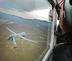
GBDAA Helps Safely Integrate Drones into the National Airspace System
Federal regulations require operators of remotely piloted aircraft, like drones and other unmanned aircraft systems (UAS), to remain well-clear of surrounding aircraft. As there is no pilot physically onboard a remotely piloted aircraft, a remote operator often resorts to mission-limiting means of seeing and avoiding other aircraft such as using a ground-based observer or a piloted chase aircraft to follow the aircraft.
To address this safety challenge, a team from U.S. Department of Transportation (DOT) Volpe Center, U.S. Air Force, Raytheon, and MITRE Corporation developed and deployed an automated solution that enables remote operators to detect-and-avoid other aircraft. This new capability provides an operational safety level equivalent to a pilot operating under visual or instrument flight rules.
This automated solution, named Ground-Based Detect and Avoid (GBDAA), uses existing air traffic data to provide remote operators with a real-time display of aircraft in the surrounding airspace. A mobile version of GBDAA, SkyVision, is the only mobile beyond visual-line-of-sight system certified by the Federal Aviation Administration to provide remote operators with real-time aircraft display data, a key component for safe integration of UAS into the National Airspace System (NAS).
GBDAA alerts remote operators to potential conflicts with neighboring aircraft, while still relying on the operator to follow normal piloting right-of-way rules if a conflict is detected. The system leverages existing NAS radar equipment and infrastructure to locate surrounding aircraft, and it can also track non-cooperative aircraft—aircraft that are not electronically broadcasting their position or speed.
GBDAA can support both daytime and nighttime operations and is compatible with all classes of UAS, which include:
- Small UAS (sUAS);
- Medium-sized UAS, such as MQ-9 Reapers; or
- Larger UAS operations, such as RQ-4 Global Hawks.
The GBDAA team is currently conducting flight operations at the Springfield-Beckley Municipal Airport in Ohio and at other NAS locations. Flight operations include training missions, as well as research and evaluation of the safety and efficiency of drone operations in a 200-square-mile test range.
The team has future plans to expand the mobility of the GBDAA platform by expanding coverage in areas where traditional surveillance sources do not reach, which would help expand the use cases of UAS such as improving security and surveillance efforts for event security, search and rescue efforts—or even disaster response activities. Expansion efforts include:
- The integration of a new mobile sensor that will help with low-altitude surveillance coverage gaps; and
- The integration of Automatic Dependent Surveillance Broadcast (ADS-B) data into the GBDAA airspace picture.

The GBDAA team at the 2019 Air Traffic Control Association Award Ceremony in Washington, D.C. (Air Traffic Control Association photo)
In October 2019, the GBDAA team received the 2019 Air Traffic Control Association’s (ATCA) Team Award for Outstanding Achievement for its work in advancing the science, safety, and efficiency of air traffic control.
In addition, in March 2020, the GBDAA team won a Performance.gov’s 2019 Gears of Government Award for exemplifying the President’s vision for a modern, effective government by producing impactful tools and ideas that better serve the American people.
To learn more about GBDAA, read about the Volpe Center’s GBDAA work, or contact the U.S. DOT Volpe Center GDBAA team lead Jason Glaneuski.
The U.S. DOT Volpe Center performed this work on behalf of the U.S. Air Force in partnership with Raytheon and MITRE Corporation.

