
Panama Canal: A New Course for the Canal
This write-up was originally featured in the Spring 1999 issue of the Volpe Journal.
The lesson of the Panama Canal is a cornerstone of grammar school geography, where students learn the significance of the canal by tracing on a globe the alternate route, all the way around South America, past treacherous Cape Horn, and north again thousands of miles each way, saved by a 45-mile canal that crosses a tiny spit of land. This lesson is borne out by the 13,000 oceangoing vessels that cross the Panamanian isthmus every year. Even in our "information age," livelihoods around the globe depend on the intercontinental movement of real goods like sugar, steel, oil, and ores. Fortunes rest on the time it takes for wheat to get from Baton Rouge to Vladivostok, or automobiles from Tokyo to Boston, or kiwi fruit from New Zealand to London.
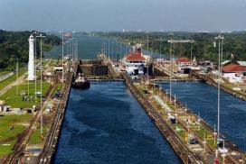
While the Panama Canal provides significant time savings, passage through this narrow waterway presents a host of challenges, especially for the "Panamax" ships, which, at 970 feet long and 105 feet wide, are the largest vessels that can pass through the canal. These oceangoing behemoths are designed for sailing thousands of miles over the open ocean, not for negotiating a shallow channel, maneuvering around oncoming vessels, or squeezing into a lock with only a few feet of leeway on either side. Canal navigation is such a complex affair that every vessel transiting the waterway (even a U.S. nuclear submarine) is directed by a canal pilot who boards the ship soon after it enters canal waters, and who is responsible for the vessel's movements until the far ocean is reached. Like river pilots on the Mississippi, these canal pilots have an intimate knowledge of the canal and its changing restrictions as water levels fluctuate and dredges operate within the channel. As pilots direct ships past landslides, around corners, and over submerged rocks, they navigate by a system of buoys and land-based range markers, originally constructed before World War II.
Based on cues from these targets, a pilot aligns the ship within the channel and recognizes when the ship must change course to embark on a new section of channel, or reach. Unfortunately, when rain or fog obscures these visual navigation aids, a pilot may be unable to determine if the ship is within its channel, drifting perilously close to the bank, or floundering in the path of an oncoming vessel.
The canal's navigation difficulties are closely tied to the impediments that hindered its creation. During construction, the area's fractured geology caused recurring landslides that severely hampered excavation; today, unstable slopes hinder efforts to widen the channel, and massive dredges and cranes with names like Titan and Hercules are constantly at work, clearing the channel of rocks and mud forced upwards by the pressure of the water. Torrential tropical rainstorms previously flooded the Chagres River, sweeping away construction equipment and laborers; now the river is tamed by two dams, but daily downpours can render radar receivers 'blind' when pilots most need the information they provide. The fog that develops almost every evening was once thought to be the precursor of malarial fever and sickness; now sailors know that malaria is transmitted by mosquitoes, and that the real danger of the fog is the speed with which it descends into the canal, and the thoroughness with which it obscures visible navigation aids.
Soon all canal pilots will have a new tool in their efforts to safely guide vessels through this difficult canal: a Communications, Traffic Management, and Navigation system designed by the Volpe Center. This new CTAN system, developed for the Panama Canal Commission by Volpe Center staff in the Center for Navigation, makes the canal safer and more efficient by using satellite data to create a real-time display that shows the location of every vessel in the canal. This space-age, bird's-eye view gives canal pilots and traffic control staff an entirely new perspective from which to view the complex choreography of 50,000-ton vessels slipping into narrow locks and scooting past one another around tight corners, even if the view from the bridge is obscured by fog or rain.
Keeping a Canal Up-to-Date
Since its inauguration on August 15, 1914, the canal has seen the transit of over 700,000 vessels. The canal is operated by the Panama Canal Commission (PCC), a binational entity organized after approval of the Panama Canal Treaties in 1979. Those treaties called for the disestablishment of both the U.S.-run Panama Canal Company and the 10-mile wide canal Zone, which has been under U.S. jurisdiction since 1908; the treaties also called for the final transfer of canal ownership and administration to Panama on December 31 of this year.
Recognizing the canal's role as a key link in the world's economy, the Panama Canal Commission continuously seeks ways to make the canal more efficient and safer. As the volume of ship traffic approaches the capacity of the canal, more efficient scheduling and traffic control are key elements of the proposed improvements. Currently, most vessels pass through the canal with a twenty-minute headway between one boat and another. Even slight complications can be compounded to cause significant delays; the master schedule for canal traffic is redrawn numerous times over the course of a day. Canal authorities installed closed-circuit television cameras at strategic vistas along the canal to monitor traffic, but these cameras are limited in their usefulness, are not helpful to canal pilots on board ships, and can only provide a view of one section of the canal at a time.
In 1995, the Panama Canal Commission contracted the Volpe Center for Navigation, a known leader in radio navigation systems, to develop a system that would track the location of transiting boats and Canal Commission "floating resources" such as tugboats and dredges. The Volpe Center was the logical choice to develop such a system. The Center for Navigation had already proven its ability with a similar navigation system it developed for the St. Lawrence Seaway Development Corporation. That system was based around a half-dozen portable units that used the Global Positioning System, or GPS, to determine their location. The portable units then transmitted that information to the shore-based control center responsible for scheduling ships waiting to pass through the locks.
While the Center for Navigation's experience in the St. Lawrence Seaway was important, the requirements for the Panama system presented many new challenges. To begin with, the scale of the project was considerably larger the Canal Commission requested 120 mobile units. In order to keep costs down and ensure on-time delivery, the Center was committed to building the system from components that could be purchased "off-the-shelf," rather than developing custom-built components. The new system was also to incorporate a key feature that could correct variations in the GPS signal to produce even more accurate location data. This feature, known as Differential GPS (DGPS), had never been applied to vessel navigation systems on such a large scale.

In order to develop the system, Dr. James Carroll, the project engineer, drew on a variety of strengths within the Center for Navigation. Programming specialists Giau Nim and Mac Craven developed the unique communications software that underlies the system. Engineers Jon Pietrak and Ted Papadopoulos built the mobile units, while others focused on the hardware of the radio relay stations and other ground-based components of the system. While each team member had a specialty, each participated in almost every aspect of the system. This spirit of collaboration extended beyond the Volpe Center to include the staff of the Canal Commission. Kam Chin, Pete Kennett, and Henry Wychorski, who set up the DGPS station and the radio network that relays information to the mobile units, consulted with Canal Commission engineers to get their advice and ensure that the new system would be compatible with existing radio hardware. While developing the user interface, Dave Phinney and Kam Chin worked extensively with canal pilots to ensure that the units displayed the most important information in a format that was easy to use. In some cases, this collaboration prompted the development of new features that were not envisioned when the system was first planned.

While participation in the project occasionally gave Volpe Center staff a chance to escape from wintry Massachusetts to sunny Panama, the field work involved many hurdles that do not occur on projects in, say, Iowa. The humidity in Panama can be so overwhelming that, even in air-conditioned offices, metal paper clips leave rust marks on papers in a matter of hours. Field work scheduling had to allow for the interminable customs delays that slow the delivery of material to Panama.

The result of all this effort is a coordinated system of 120 mobile units that communicate with a control center via a shore-based communications network. The mobile units consist of a GPS receiver and antenna, a laptop computer, and another radio antenna for communications with the control center. Roughly half of the mobile units are permanently installed on floating resources such as tugboats and dredges. The remaining units are carried by canal pilots onto transiting vessels.
The Global Positioning System is a worldwide navigational aid based on a constellation of 24 orbiting satellites. GPS units receive transmissions from these satellites and calculate their own location based on the geometry of the received signals. Since each satellite provides one measurement from which the receiver's position can be triangulated, transmissions from more satellites provide more accurate locations. GPS units in Panama can receive up to ten satellite signals, resulting in robust geometry and extremely accurate location data. Due to national security concerns, the transmissions from all GPS satellites include a fluctuating inaccuracy that varies with time but is consistent within a broad geographic area. To overcome this inaccuracy, the CTAN GPS units receive correction signals from a GPS unit permanently installed at a fixed, surveyed location on the shore. This reference station, whose transmitter was provided by the U.S. Coast Guard, constantly measures the variation of the GPS signal and transmits this information to the mobile unit so it can combine this differential with the signal it receives. Using this correction, the CTAN GPS units can determine their location to within one meter (three feet) and can provide remarkably accurate speed measurements. This type of GPS system, where a fixed unit transmits corrections to one or more mobile units, is known as Differential GPS.

Once the mobile GPS unit has determined its location, it transmits this information to the shore-based control center via a 9600-baud transmitter operating near 500MHz. Six Ultra High Frequency (UHF) radio data link stations provide complete coverage of the canal, even within the deepest parts of the Gaillard Cut. The control center receives this data, compiles it with data from all the other mobile units and retransmits the entire picture back to the mobile unit via the same UHF data links. This way, each unit will transmit its own location and receive the locations of all other ships in the canal. The full information is updated every few seconds.
The system display is compatible with a regular Microsoft Windows environment. During the design phase of the project, Volpe Center staff worked closely with canal pilots in order to ensure that the pilots could efficiently access the information most important to them. With the click of a mouse, a pilot can change magnification or access the name, size, tonnage, country, heading, and speed of any other ship in the canal. The system also incorporates data from the harbor radar, so boats that have not yet been boarded by canal pilots will be visible on the display.

The extensive collaboration between canal pilots and Volpe staff led to a very effective new feature. Volpe staff expanded the computer program to calculate the location where two vessels in the same section of canal will pass each other, and programmed the display to highlight this location and indicate the estimated time to that meeting. Using this information, pilots can modify their speed in measured ways, so as to adjust the intercept point to a safe location (e.g., not at a bend). The canal pilots have already made it known how useful this feature is. This type of collaboration was vital to ensuring the buy-in of the pilots. Their job is so complex that they must have complete confidence in the tools they use. If, without that input, Volpe staff had tried to "go ahead and design it, and to tell them what they want," says Jim Carroll of the Volpe Center, "they probably would have taken the unit and thrown it into the water with the case open." By working together, they developed a tool that exceeds expectations.
In August of last year, the new system proved its worth by preventing a potentially serious accident. A 740-foot long bulk carrier in Gatun Lake, transiting north from the Pacific to the Atlantic, was making a transition from Bohio reach to Buena Vista reach during a heavy rainstorm. When the rudder was straightened, the ship continued to turn, and eventually stopped crosswise in the channel. Meanwhile, a 600-foot car carrier was traveling in the opposite direction in Buena Vista reach. Although his radar was 'blind' due to the heavy rain, the pilot of the car carrier looked at the CTAN screen in time to see that the bulk carrier was directly in front of his vessel and across its path. The car carrier's pilot directed his ship to stop on the west side of the channel so the bulk carrier could get straightened out. Both pilots stated that without the aid of the CTAN unit, they would not have had the information necessary to prevent a collision between the two vessels, and a Commission employee noted that, based on the approach angle, "the results would not have been pretty."
While the CTAN system has already demonstrated its usefulness, it also incorporates one key feature that will prove even more useful in the future: flexibility. Volpe staff designed the system to be amenable to enhancements. Already, a new DGPS reference station is under construction on the Atlantic side of the canal. This new station, eight times more powerful than the existing prototype station, will provide a stronger signal and continued accurate location data. In addition, the mobile unit may someday include a second GPS receiver antenna. By integrating the corrected GPS signal from two antennae, the expanded system will be able to calculate with great accuracy the heading and rate of turn of the vessel. This detailed navigation information will prove invaluable in low visibility conditions, during precision operations, and when ships are entering the locks or passing one another.

Because this adaptability is such an integral part of the new CTAN system, it is a tool that will be useful to canal pilots for years into the future. Even if the Gaillard Cut is again widened, and even if a third, larger set of locks is constructed, one thing is sure: the Panama Canal will continue to present challenges. It baffled engineering minds for centuries, ruined one of the world's foremost entrepreneurs, and killed thousands of laborers. Its construction demanded the attention of the United States for almost ten years; eighty years later, it continues to give heartburn to seasoned canal pilots. Since the sixteenth century, great minds have turned their attention to the canal; when the time is right, as it was in 1908, the confluence of innovation and technology can yield remarkable results. Now, the Volpe staff members who worked on this project have added their names to the list of great engineers, technicians, and laborers who have tackled this endless parade of challenges. As they combined their own ideas with the available technology, they developed a tool that reinvents the experience of navigating a vessel through the canal. Like all the workers who planned the canal, drove the steam shovels, poured the concrete, designed the lock gates, and dredged the channel, they have made a new Panama Canal.
Ninety years ago, the United States built the Panama Canal by combining innovative engineering strategies with state-of-the-art technology. Now the time has come to create a modern navigation system for the canal, and this time, Volpe is providing the know-how.