
This Long-Range Transportation Plan is a First for the National Park Service
The roads, bridges, and transit systems in our national parks are a little different from most other transportation networks across the country.
They don’t move great volumes of freight, but they do move large numbers of visitors. They don’t exist to enable economic growth, but they do support economic activity. The National Park Service (NPS) wasn't created to help people commute to and from work, but its parkways are used by tens of thousands of commuters each day.
So what do the transportation networks across the NPS do? They allow the public to enjoy, learn from, and be inspired by the country's vast natural and cultural resources.
“Transportation in the NPS context is multimodal—it’s more than roads and bridges,” said Volpe planner Kevin McCoy. “Some areas are only accessible by other means, like trails, ferries, airplanes, or public transportation. And so for NPS to meet its goal of providing access, it’s important to keep all these different modes functioning safely and efficiently.”
Great Interest, Great Access
From the historic carriage roads laid by hand in Acadia National Park to trailhead parking lots in Yosemite, transportation assets in America’s national parks are seeing record numbers of visitors.

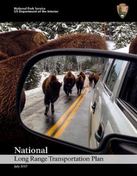
This roadway in Zion National Park in Utah is among the 5,500 centerline miles of paved roads in the NPS Paved Road and Bridge Network. (NPS photo)
To provide service-wide guidance on maintaining and improving those assets, NPS recently released its first National Long Range Transportation Plan (LRTP), a 20-year vision that a team of Volpe planners, including McCoy, helped NPS develop.
“The NPS has two missions: protecting natural and cultural resources, and providing access for visitors to enjoy those resources,” said Bryce Lloyd, LRTP program manager for the NPS Facilities Planning Branch. “That’s why our National LRTP emphasizes resource protection and visitor experience—two goals that feature prominently in our plan but aren’t typically emphasized in state or metropolitan area LRTPs.”
The NPS National LRTP provides comprehensive analysis and recommendations covering transportation investment priorities for an expansive system that has 5,500 centerline miles of paved roads, 120 million square feet of paved parking areas, more than 1,400 bridges and tunnels, 4,600 miles of trails, 950 trail bridges, 130 transit systems, and 130 miles of constructed waterways.
“The NPS National LRTP is consistent with new standards in performance-based planning,” said McCoy. “That means transportation condition and investment strategies are based on data. Specifically, in this plan there are 14 performance measures with baselines and targets.”
Financial Realities Lead to Investment Priorities
From 2006 to 2013, NPS invested about $461 million each year in transportation assets and services.
For 2015 to 2020, NPS forecasts having $394 million available per year.
But NPS estimates it needs $1.5 billion per year to bring all of its transportation assets into good condition.
The National Transportation Investment Strategy within the NPS LRTP helps address this $1.1 billion shortfall by focusing almost all transportation funding on highest priority assets—those that the majority of visitors use.
It also improves the balance of investments between paved roads and bridges and other assets, like trails and transit systems. The investment strategy emphasizes funding for preventive maintenance, which keep assets in good condition longer and extends their useful lives. Timely preventive maintenance is almost always less expensive than replacing a deteriorated asset.
Making the Most of Every Dollar
Like nearly all state and local governments, NPS strives to make the most of every dollar. To do that, the LRTP introduces a new financial analysis framework, which McCoy and other Volpe transportation experts helped develop.
“The National LRTP provides system-wide strategies, goals, and objectives,” McCoy said. “These concepts filter down to NPS regions, which have their own LRTPs that affect how plans and investment decisions are made at those levels. The new methodology for national-level financial analysis and rich baseline data is feeding into other regional and unit plans, and we are updating and expanding the dataset and developing tools to make that easier.”
Next year, NPS will wrap up a suite of transportation plans for each of its seven regions with the release of an LRTP for its National Capital Region. NPS created many of these plans using Volpe financial and planning analysis.
To meet performance-based planning and programming goals for NPS transportation systems, Volpe will lead service-wide performance management analyses for these first-ever national and regional LRTPs. These analyses will help NPS gauge how well it is meeting the goals and objectives established in these plans, and will allow NPS to adjust and update the plans as needed.
Read the full National Park Service Long Range Transportation Plan.
The National Long-Range Transportation Plan is a first for the National Park Service.